Chapter 13 — The Great Banana Fishery
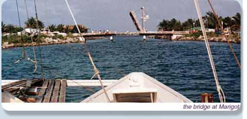
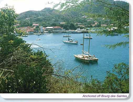
The next stop on the trip north was at the Iles des Saintes off the south coast of Guadeloupe, bypassing Dominica. As I poked my nose around the high northern tip of Martinique I was hit by a violent gust of wind. It took a little while to realize that this was actually not a gust, but the steady-state wind! I dropped the main and with reefed mizzen and the small jib, a total of a hundred and eighty square feet, I continued to windward at six knots. In the lee of Dominica progress was intermittent with calms and gusts, but I finally made it around the north end of the island and out into the open again. The wind was now farther out on the beam, and with long high rollers coming in from the Atlantic it was quite an exhilarating sail. Half way to the Saintes I saw something brown on the water ahead; it turned out to be a mass of disintegrating cardboard banana cases and the sea was covered with green bananas—they must have fallen off a ship. I did not fancy stopping in the prevailing conditions, but on the way through I managed to snag four large hands with my dip-net. Later I was able to give half of them away, but I still spent a couple of weeks eating banana bread, banana cookies, banana toast, bananas on cereal and just plain bananas (URP!) There were a few anxious moments as I approached the islands until I finally identified the Passage des Dames and swept through in fine style with swells breaking on the rocks on each side. Inside a couple of fishermen in an open boat gave me a cheery wave as I rounded up into the little harbour of Bourg des Saintes. These islands were once the home of hardy and independent fishermen. They are still here, but a new industry has grown up, day trippers from Guadeloupe. The little village is delightful with its flowers and pretty sidewalk cafes. Across from the miniature town hall (complete with its 'Liberte Egalite Fraternite' inscription) is a park of flowering shrubs, palms, fountains and benches. On the hill above the town stands Fort Napoleon in an excellent state of preservation (in fact it was used by the Vichy government to house Free French prisoners during WW II). Today the fort houses a gallery of contemporary Caribbean art and a museum with a major display on the Battle of the Saintes in which the British under Rodney defeated DeGrasse and the French to acquire control of Caribbean waters. In fact I noticed that the first shot of the battle was fired very close to where I found the bananas, but I cannot imagine that there was any connection. Bourg des Saintes is not a port of entry, but yachtsmen are considered to have done their duty if they check in with the gendarme. A couple of days later a Police Maritime boat came over from Pointe aux Pitres on Guadeloupe and did the rounds of the foreign yachts in harbour. This was the first time on the whole trip that I had any kind of official aboard Oborea, and this was just because it was easier to fill in forms on my deck than in his Zodiac. In Bourg des Saintes I met Michel and Francoise, a French couple aboard a Wharram TIKI 31 Poinsettia. Michel had pre-fabricated the boat in France, shipped the parts across, and built her in Guadeloupe. They now leave her there when they return to France each summer. I spent a week in the Saintes, going for day sails through the islands on Poinsettia or Oborea, and then it was off again to the north. The guide book says the passage up the west coast of Guadeloupe is rather boring, but it was the first time that I carried a favourable wind almost the whole way through the lee of an island so that I had time to relax and admire the beautiful green mountains and valleys. I stopped overnight in Deshays Bay at the north west corner of the island before the forty mile crossing to Antigua. I was heading for English Harbour on the south coast of the island and I had a quick crossing with the sheets just started. The entrance to the harbour is notoriously hard to find, being just a narrow gap in the cliffs, so I headed a few miles to windward and then followed the coast until the dog-legged entrance opened up right under my bow. I was a little dismayed to find the outer part of the harbour absolutely packed with yachts, but I picked my way through and rounded the corner off Nelson's Dockyard to find Ordinance Bay, the inner part of the harbour and traditional little ship anchorage, half empty; beautifully calm and peaceful after the boisterous Caribbean. Nelson's Dockyard is supposed to be the best preserved eighteenth century naval dockyard in the world. It has been largely restored and is now a national park. Big yachts anchor stern-to off the dockyard, and there were some immense floating palaces just like in Florida. For the first time in eleven month's cruising, North American yachts were again in the majority. Amongst the monsters and looking quite tiny at forty nine feet: the Hiscocks' old Wanderer IV. All the buildings ashore are used—stores, boutiques, charter offices, yacht brokers, restaurants, bakery, gifte shoppes a beauty salon and a museum, all in eighteenth century stone buildings. There are some lovely walks from the harbour up into the hills of Shirley Heights—grassland with prickly shrubs and cactus—to the cliffs overlooking the sea to the south. Most of the island can be seen from these heights as well as an aerial view of English Harbour and Falmouth Harbour beyond it. Everywhere there are remains of eighteenth century British military installations—Georgian facades and columns rising out of the bush. I left Antigua in mid afternoon for an overnight passage to Sint Maartin. To the southward Monserrat, Nevis and St Kitts were visible through the haze as I made rapid progress with the wind on the starboard quarter. I passed a Prout catamaran and an American ocean going tug with a barge. In fact I made such quick progress that I passed just south of St Barts at midnight and was anchored in Groot Baai, St Maartin by three in the morning. St Maartin is only seven miles across, but has an international border through the middle. The southern part is Dutch, and the northern, St Martin, is French. The whole island is a free port and there is no customs service. Philipsburg is the capital of the Dutch half, and although official signs are in Dutch, and the official currency is the guilder, English is the universal language and the American dollar the universal currency. The principal industry seems to be serving the big cruise ships that stop here for the casinos and duty free shopping. The town is tiny but has huge stores selling perfumes, jewellery, watches, cameras and electronics-all at incredibly low prices. In the supermarket I found rum at what I thought was $3.50 a bottle; this turned out to be guilders and converted to $1.95 American! In the centre of the island is a large lagoon that the chart makers, in a fit of linguistic indecision, have called Grand Etang de Simsonbaai. There are entrances on both sides of the island crossed by drawbridges, with marinas inside, however most yachts are unable to cross the lagoon because of a shallow bar in the centre. This was no obstacle to Oborea's two and a half foot draught, and I crossed to the French capital of Marigot. This was much prettier than Philipsburg, with no huge duty-free emporia or casinos, just lots of flowers, colourful sidewalk cafés and gendarmes in kepis and short shorts. The bridge on the French side was an old and decrepit affair hauled up by cables. It looked narrow, and no one I asked knew exactly how wide it was, but they all thought it was wide enough for Oborea's five point seven meter beam. The channel was too narrow to turn around, so with the wind and current astern and a lot of apprehension I headed for the bridge as it slowly creaked open. The narrowest part of the structure was about six feet above the water, just the right height to slice off the rigging, but we made it through with at least eighteen inches to spare on each side. I left for the British Virgin Islands after dark as I wanted to make a daylight arrival and the crossing was uneventful except that the first two lights I picked up were not marked on my chart, and I never did see the light on Ginger Island that I was aiming for. However as the sun rose I was able to identify Round Rock Passage from the 1848 view in the British Pilot Book and sailed through into Sir Frances Drake Channel for the ten mile run to Road Town on Tortola where I anchored in time for breakfast.